Online:Ebonheart Territory
< Elder Scrolls Online: Places: Cyrodiil / Subzones(Redirected from Online:Sejanus Hunting Grounds)
|
||||
|---|---|---|---|---|
| Zone | ||||
| Cyrodiil | ||||
| Location | ||||
| Northeastern Cyrodiil | ||||

The Ebonheart Territory in Cyrodiil initially comprises the northeasternmost regions. The six keeps that make up the initial defenses of the Ebonheart Pact are all located here. In addition, the towns of Cheydinhal and Cropsford can be found in the central and southern regions, respectively. The Imperial City lies across Lake Rumare to the west, but is inaccessible. The Aldmeri Territory is separated by the Niben River to the southwest, and there are three defensible bridges that cross it. The Daggerfall Territory lies across a mountain range to the northwest, with three gated passes. Swimming across the river or Lake Rumare is inadvisable, as they are rife with Slaughterfish. There are three Dolmens here; the Eastern Shore Dolmen and Niben Basin Dolmen are found in the west, and the Cheydinhal Foothills Dolmen is on the eastern edge of the territory.

Broke Pick RavineEdit
Broke Pick Ravine is situated south of Kingscrest Keep. It is a lightly wooded area on the snowline of the Jerall Mountains which contains a small lake. A road runs down the western side of the region from Kingscrest Keep towards Arrius Keep.

Cheydinhal FoothillsEdit
The Cheydinhal Foothills are located south of the city of Cheydinhal, and are foothills of the Valus Mountains. The Blue Road runs along the north of the region from Blue Road Keep through Cheydinhal and towards the Gate of Ghartok. The Burned Estate and Barren Cave can be found in the western hills, just east of Blue Road Keep. Harlun's Watch and The Steed Mundus Stone are just south of the city, with Thorn Lodge and Quickwater Cave situated to the north. The Cheydinhal Foothills Dolmen, Scinia Ruins, and the Ayleid ruin Kemen can be found on the eastern side of the region.

Eastern ShoreEdit
The Eastern Shore of Lake Rumare sits to the west of Blue Road Keep, and runs north from the Eastern Shore Dolmen to Urasek Ruins. The Red Ring Road cuts up the side of the region past Magia Ruins and a large Imperial Outpost towards Chalman Keep.

Frost FieldsEdit
The Frost Fields are situated in the far north of the territory, north of Kingscrest Keep. The sparsely-forested region contains a number of rocky outcrops, and a destroyed dolmen can be found in the center. The Winter Gate into the Daggerfall Territory can be found in the west of the region, and a road runs from here to the Gate of Chim in the east.

Horunn PassEdit
Horunn Pass is located west of Kingscrest Keep, and contains the Horunn Milegate into the Daggerfall Territory. The region is littered with both evergreens and deciduous trees. The Ayleid ruin of Sedor sits in the northern section of the region, while the Horunn Outlook looks out over Wilminn's Winery to the south.

Mist Morrow ValeEdit
Mist Morrow Vale is a large wooded region in the east of the territory north of Drakelowe Keep. The Reed River runs down the eastern side of the region, and a tributary flows through the valley from west to east. Waterside Mine sits on the south side of this tributary. Lake Poppad can be found in the west of the region, with Muck Valley Cavern on its western shore, Vaermina's Shrine on the eastern side, and the Arvina Estate to the south. Atop the hill between Lake Poppad and the Reed River stands Crooked Finger Redoubt, which looks down over the Ayleid ruin Vahtacen. Mist Morrow Tower lies on the hill on the southern side of the vale.

Northeastern ShoreEdit
The Northeastern Shore of Lake Rumare is situated southwest of Chalman Keep and runs from Urasek Ruins in the south to the border with the Daggerfall Territory in the west. Lake Mist Ruins can be found on the shoreline, with an entrance to the Imperial Sewers further around to the northwest. An access road leads down to this entrance from the Red Ring Road near Chalman Lumbermill, while Thaellin's Shack can be found just inland. A bridge to the Imperial City also leaves from the northeastern shore, but it is inaccessible due to the Daedric invasion.
Lionesses reside on the slope leading towards the water.

Northern Niben BasinEdit
The Northern Niben Basin is the region west of Drakelowe Keep and north of Cropsford on the eastern side of the Niben River. The region consists of rolling hills and wooded valleys through which the Yellow Road passes on its way from Alessia Bridge towards Drakelowe and the southeast. Agrippa Mento's House can be found on the side of the road near the entrance to Cracked Wood Cave. Northeast of the entrance, the cave roof has collapsed into a large sinkhole, which offers a second entry point to the cave. The Shadow stone is just east of this sinkhole, and the Ayleid ruin of Nornal can be found just outside Drakelowe Farm. The Niben Basin Dolmen is situated in the north of the region.

Sejanus Hunting GroundsEdit
The Sejanus Hunting Grounds can be found to the east of Sejanus Outpost. Primarily open plains, the northern part of the region has become blighted by undead spewing out of the Ayleid ruin Nagastani.

Southeastern ShoreEdit
The Southeastern Shore of Lake Rumare lies to the west of Sejanus Outpost and runs from the Alessia Bridge over the Niben around to the Eastern Shore Dolmen. A small lake sits just to the south of the Magia Ruins.

Southern Niben BasinEdit
The Southern Niben Basin is the region southwest of Drakelowe Keep and south of Cropsford on the eastern side of the Niben River. The region is littered with rocky outcrops and tree-covered hills which lead down to the banks of the Corbolo River. A southbound road through Cropsford splits just south of the village, with the eastern spur passing Timberscar Hollow and the Hedoran Estate before dead-ending at the Corbolo next to the entrance of Newt Cave. The western spur passes Crown Point and the Abandoned Homestead before crossing Niben Bridge into the Aldmeri Territory. A road leads off of this up the side of the Niben past the Ayleid ruins of Culotte to the Culotte Bridge.

Summer's PastureEdit
Summer's Pasture is located east of Chalman Keep and north of Blue Road Keep. Primarily a farming region, a number of ruined buildings can be found around the rocky crags and autumnal trees. The Ayleid ruin of Belda is situated in the south of the region, while The Ritual stone can be found in the center of the pasture.

White Fall ValleyEdit
White Fall Valley lies to the north of Farragut Keep and encompasses the north and east side of the eponymous White Fall Mountain. At the northern end of the valley, just outside Kingscrest Keep, the Temple of the Ancestor Moths houses the legendary Elder Scrolls. Just to the south, the road splits, with the western trail passing the Shurgak Clan Estate and The Tower stone at the foot of White Fall Mountain, and the eastern path passing Kingscrest Cavern and Fanacas before reaching Farragut. Lake Arrius can be found on the south side of the mountain in the grounds of Arrius Keep.
Strangely, for the purposes of achievements, White Fall Mountain is considered separate from Ebonheart Territory and has a separate achievement for obtaining the Skyshard located there. As such, this Skyshard is not required for the Cyrodiil Pact Skyshard Hunter achievement.
PlacesEdit
Major SettlementsEdit
 Cheydinhal — A city in eastern Cyrodiil, southeast of Arrius Keep. (map)
 Cropsford — A town in southeastern Cyrodiil, southwest of Drakelowe Keep. (map)
Minor SettlementsEdit
 Burned Estate — An estate in eastern Cyrodiil, east of Blue Road Keep. (map)
 Crooked Finger Redoubt — A small fort in eastern Cyrodiil, north of Drakelowe Keep. (map)
- Harlun's Watch — An abandoned homestead located in eastern Cyrodiil, south of Cheydinhal. (map)
- Hedoran Estate — An estate in southeastern Cyrodiil, southeast of Cropsford. (map)
- Shurgak Clan Estate — An estate in northeastern Cyrodiil, northwest of Farragut Keep. (map)
 Temple of the Ancestor Moths — A temple in northeastern Cyrodiil, southeast of Kingscrest Keep and southwest of the Scroll Temple of Chim. (map)
- Wilminn's Winery — A vineyard in northeastern Cyrodiil, east-northeast of Chalman Keep. (map)
Border Keeps, Artifact Gates and Scroll TemplesEdit
 Northern Morrowind Gate — A border keep in northeastern Cyrodiil, far northeast of the Imperial City. (map)
- Southern Morrowind Gate — A border keep in northeastern Cyrodiil, far northeast of the Imperial City. (map)
 Gate of Chim — The gate guarding the Scroll Temple of Chim. (map)
- Gate of Ghartok — The gate guarding the Scroll Temple of Ghartok. (map)
 Scroll Temple of Chim — The seat of the Elder Scroll of Chim, the defensive scroll for the Ebonheart Pact. (map)
- Scroll Temple of Ghartok — The seat of the Elder Scroll of Ghartok, the offensive scroll for the Ebonheart Pact. (map)
Keeps and OutpostsEdit
 Arrius Keep — A keep in northeastern Cyrodiil, northeast of the Imperial City. (map)
- Blue Road Keep — A keep in central Cyrodiil, east of the Imperial City. (map)
- Chalman Keep — A keep in central Cyrodiil, northeast of the Imperial City. (map)
- Drakelowe Keep — A keep in eastern Cyrodiil, east of the Imperial City. (map)
- Farragut Keep — A keep in northeastern Cyrodiil, northeast of the Imperial City. (map)
- Kingscrest Keep — A keep in northeastern Cyrodiil, northeast of the Imperial City. (map)
 Harlun's Outpost — An outpost in northern Cyrodiil, south of Cheydinhal. (map)
- Sejanus Outpost — An outpost in central Cyrodiil, southeast of the Imperial City. (map)
Imperial MilegatesEdit
 Alessia Bridge — A bridge in southern Cyrodiil, northeast of Castle Alessia, acting as a milegate between Dominion and Pact territories. (map)
 Chalman Milegate — An Imperial milegate in northern Cyrodiil, southwest of Chalman Keep, on the border between Pact and Covenant territories. (map)
- Culotte Bridge — A bridge in southeastern Cyrodiil, west of Culotte, acting as a milegate between Dominion and Pact territories. (map)
- Horunn Milegate — An Imperial milegate in northern Cyrodiil, northwest of Wilminn's Winery, on the border between Pact and Covenant territories. (map)
- Niben Bridge — A bridge in southeastern Cyrodiil, northeast of Castle Bloodmayne, acting as a milegate between Dominion and Pact territories. (map)
- Winter Gate — An Imperial milegate in northeastern Cyrodiil, northwest of Kingscrest Keep, on the border between Pact and Covenant territories. (map)
Ayleid RuinsEdit
 Belda — An Ayleid ruin in eastern Cyrodiil, north of Blue Road Keep. (map)
- Culotte — An Ayleid ruin in southeastern Cyrodiil, west of Cropsford. (map)
- Fanacas — An Ayleid ruin in northeastern Cyrodiil, northwest of Farragut Keep. Spirits and skeletons roam the ruins. (map)
- Lake Mist Ruins — An Ayleid ruin in Cyrodiil, south of Chalman Keep. (map)
- Nagastani — An Ayleid ruin in eastern Cyrodiil, south of Blue Road Keep. (map)
- Nornal — An Ayleid ruin in eastern Cyrodiil, west of Drakelowe Keep. (map)
- Sedor — An Ayleid ruin in northeastern Cyrodiil, west of Kingscrest Keep. (map)
DungeonsEdit
 Cracked Wood Cave — A cave in southeastern Cyrodiil, just northwest of Cropsford containing Bloody Hand goblins. (map)
- Kingscrest Cavern — A cave in northeastern Cyrodiil, southeast of Kingscrest Keep containing spiders and spriggans. (map)
- Muck Valley Cavern — A cave east of Sejanus Outpost in eastern Cyrodiil, containing goblins, kwama, and giant spiders. (map)
- Newt Cave — A cave in southeastern Cyrodiil, southeast of Cropsford containing wildlife. (map)
- Quickwater Cave — A cave in northeastern Cyrodiil, southeast of Arrius Keep containing Black Daggers. (map)
- Vahtacen — An Ayleid ruin in eastern Cyrodiil, between Drakelowe and Farragut Keeps containing undead. (map)
DolmensEdit
 Cheydinhal Foothills Dolmen — A Dark Anchor spawn point east of Cheydinhal in eastern Cyrodiil. (map)
- Eastern Shore Dolmen — A Dark Anchor spawn point southwest of Blue Road Keep in central Cyrodiil. (map)
- Niben Basin Dolmen — A Dark Anchor spawn point east of Castle Alessia in southeastern Cyrodiil. (map)
Mundus StonesEdit
 The Ritual — A Mundus Stone found in Malabal Tor, Alik'r Desert, Eastmarch, and Cyrodiil. (map)
- The Shadow — A Mundus Stone found in Greenshade, Rivenspire, Shadowfen, and Cyrodiil. (map)
- The Steed — A Mundus Stone found in Reaper's March, Bangkorai, the Rift, and Cyrodiil. (map)
- The Tower — A Mundus Stone found in Grahtwood, Stormhaven, Deshaan, and Cyrodiil. (map)
Points of InterestEdit
 Cropsford Armory — A workshop in southwestern Cropsford where items in the Dauntless Combatant set can be crafted. (map)
 White Fall Mountain — A giant camp located northeast of Arrius Keep in northeastern Cyrodiil. (map)
Other LocationsEdit
 Barren Cave — A cave in eastern Cyrodiil, east of Blue Road Keep. (map)
 Waterside Mine — A mine in eastern Cyrodiil, north of Drakelowe Keep. (map)
WayshrinesEdit
 North Morrowind Gate Wayshrine — Located inside the Northern Morrowind Gate keep. (map)
- South Morrowind Gate Wayshrine — A border keep in northeastern Cyrodiil, far northeast of the Imperial City. (map)
Unmarked LocationsEdit
- Abandoned Homestead — An estate in southeastern Cyrodiil, south of Cropsford. (map)
- Agrippa Mento's House — A house in eastern Cyrodiil located across the river from Castle Alessia. (map)
- Arvina Estate — A house in eastern Cyrodiil located on the shore of Lake Poppad. (map)
- Crown Point — A watchtower in southeastern Cyrodiil, south of Cropsford. (map)
- Horunn Outlook — A ruined fort in northeastern Cyrodiil, northeast of Chalman Keep and just east of Horunn Milegate. (map)
- Imperial Outpost — A camp in central Cyrodiil, just west of Blue Road Keep. (map)
- Kemen — A small Ayleid ruin in northeastern Cyrodiil, south of Farragut Keep. (map)
- Lake Arrius — A lake in northeastern Cyrodiil, just east of Arrius Keep. (map)
- Magia Ruins — A ruined fort in central Cyrodiil, southwest of Blue Road Keep. (map)
- Mist Morrow Tower — A ruined tower in eastern Cyrodiil, northwest of Drakelowe Keep. (map)
- Scinia Ruins — A ruined fort in eastern Cyrodiil, southeast of Farragut Keep, east of Cheydinhal, and just south of Cheydinhal Foothils Dolmen. (map)
- Thaellin's Shack — A camp in central Cyrodiil, just west of Chalman Lumbermill. (map)
- Thorn Lodge — An estate in eastern Cyrodiil, southeast of Arrius Keep and just northwest of Cheydinhal. (map)
- Timberscar Hollow — A cave in southeastern Cyrodiil, southwest of Drakelowe Keep and just southeast of Cropsford. (map)
- Urasek Ruins — A ruined fort in central Cyrodiil, northwest of Blue Road Keep. (map)
- Vaermina's Shrine — A Daedric shrine in eastern Cyrodiil, southeast of Blue Road Keep and east of the Muck Valley Cavern. (map)
GalleryEdit
-
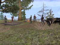
Reveler camp in White Fall Valley
-
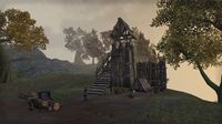
Gray Viper lookout post on the Eastern Shore
-
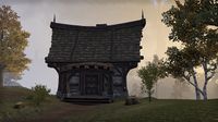
An abandoned home with a Slaughterfish Warning nailed to the front
-
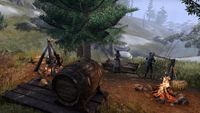
The Mothril family camp near Broke Pick Ravine


