 01:09, 27 May 2014 (GMT): I'm back playing Skyrim once again. I am not in ESO, so please don't ask.
Userspace Links
Sandboxes
|
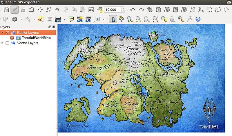
My Mapping Workspace This is my digitizing workspace in QuantumGIS. I have imported as a raster layer the highest resolution map of Tamriel that I could find online. Resources
Map ScaleI have read a lot about peoples opinions of the size of Tamriel, and how big Nirn is in general. There are many different theories out there. One of the best comments I have seen on this issue is the quote below.
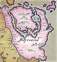
If you think about it, would you really expect to see so few people wandering around in the Imperial City? It is the capitol city of the Empire, after all. Consider also that in 3E 401, the population of Daggerfall alone stood at 110,000[1]. The population must have been scaled down for all the TES games, in order to conserve memory resources. Less population means less accommodation was required (even though there are many homeless NPC's), which in turn equates to less real estate being required to be created in-game. I'm still not sure how all of this is going to relate to the map I am creating. What I am intending to do, however, is to draw the coastline first, which includes individual polygons for each region or island nation, then place a footprint of a town (like this one) at the relevant location, and scale the town internally so that a single building will have a realistic scale. From there I can estimate a realistic scale between two towns externally, which by extension will give me an overall scale for the map. That is the plan at present, anyway. If anyone can suggest a better way to do this, I'm keen to hear. Canonical InformationOn a clear day (an exceedingly rare event), the peak can be seen from Almalexia, 250 miles to the south.[2] The only canonical information we have available about the size of Tamriel is that the peak of Vvardenfell can be seen from Almalexia, which is 250 miles to the south.[2] This gives us a starting point for calculating distances, but it is still only a very rough guide. The ProblemWhere exactly is the 250 miles measured to? Is it from the peak of Vvardenfell to the city walls of Almalexia, or to the absolute center of the city? Another problem is that the city of Almalexia doesn't appear on any recent maps, only the city of Mournhold does, which is said to be contained within Almalexia. If we now take our quandary over the difference between the perimeter and the center of Almalexia, and throw in the difference between the perimeter of Almalexia as opposed to the perimeter (or center) of Mournhold, our measurement could easily be off by a good 10 miles or so. Furthermore, the official maps released by Bethesda are indicative only, and are heavily stylized. For instance, if you look at the map of Morrowind shown on this page, Vvardenfell is lying flat, with the position of the peak being at a more northern latitude than the base of the mountain. An accurate map would show a true top-down view, with topographical contour lines. The peak of Vvardenfell would then most likely be seen as a small circle on such a map. If you try to measure distance on a stylized map, where exactly is the peak meant to be? Assumptions
CRS and Projections of NirnI have not been too worried about a Coordinate Reference System just yet, as I am assuming Tamriel to be a flat grid, rather than a globe. There appears to be no extant georeferencing evidence to support the claim that Nirn is a globe, despite what loremasters and certain in-game texts may say. The only official evidence that I can find is inconclusive, including...
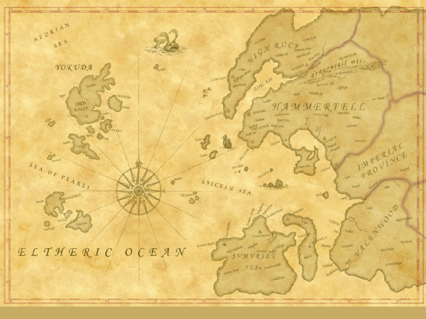
...neither of which are useful for georeferencing. The only official map we seem to have available that has any sort of coordinates on it is this one...  ...and it only has undefined latitude and longitude marks. We don't know if these marks are in degrees, miles, kilometers, or some other measure. What we do know is that they are equidistant, and that is an interesting fact. If you look at a map of our Earth, the marks between the longitude lines should vary, getting closer together the further they are from the equator. Similarly, the latitude lines should get closer together the nearer they are to the poles. (See Wikipedia for more details). However, the West Tamriel map has equidistant latitude and longitude marks, meaning that the map was drawn using an Equirectangular projection, which has a "particularly simple relationship between the position of an image pixel on the map and its corresponding geographic location"[oog 2]. Flat Nirn TheoremFor the reason mentioned above, I am going to postulate a "Flat Nirn Theorem". I already hear the collective gasp from the Loremasters here on UESP. Don't panic. I'm only claiming a "Flat Nirn" in so far as map images are concerned. Clearly, the same reason that NASA World Wind uses an Equirectangular projection, is the same reason that maps of Tamriel always appear so — it is easier to display them on a computer, using pixels. However, if we assume that Nirn is, in fact, a globe, then for all extant maps of Tamriel, the further from Nirn's equator you go, the less accurate the distances would become. Reason For a Vector Map of TamrielAs you may have seen already, I am very stringent on realism in my fan fiction writing. If I am going to say, for example, that one of my characters walked from Bruma to Helgen over the Pale Pass in three days, then I want to be sure that this is realistic. In-game time is relative, and is not really a good measure to use for distances. As mentioned in the article about game time in Oblivion, "it is sometimes faster to travel to a location without using Fast Travel". Another factor to consider is terrain. Could a character travel as fast up the Jerall Mountains, as they could across the plains of the Ashlands? Measuring distance "as the crow flies" is not always the best when telling a tale about a fictional world, as it removes some of the realism of having to think about events that may occur along the journey. An all-action tale may mention that the lead character was beset by bandits along the Green Road, and perhaps detail the fight sequence. For my own writing style, I would question where along the Green Road this happened, and why the bandits picked that particular location to stage an ambush. That is why I want a vector map, one that has topographical information, vegetation and road surface information, and that I can query using geospatial tools such as a closest feature finder. This should all be possible. It is a massive undertaking, I know, and the world of the Elder Scrolls is expanding all the time. Maybe such a map will be irrelevant when Elder Scrolls Online is released. Or maybe it will become a vital resource for ESO players. Geopolitical Shape of TamrielWhat I am having problems with at present is, how the flow of time affects the geopolitical shape of Tamriel. For instance, If I group the outlying islands together with their parent regions, where does Solstheim sit? Is it part of Skyrim, or is it part of Morrowind? This really seems to be determined by the time at which my map is based. If I say this is a map from the third century of the Fourth Era, then Solstheim belongs with Morrowind. However, my fan fiction writing is very much tied up with history, so I may need to visually represent the same location from different geopolitical perspectives.
From reading the above quote on the UESP forums, I have come to the decision that my map needs to be able to reflect geopolitical change. That said, there are also geological changes in evidence throughout the history of Nirn. For instance, the disappearance and subsequent return of the Isle of Artaeum, and the Atlantean catastrophe that befell the western continent of Yokuda. What I intend to do is to have multiple layers in my map, showing the different geological and geopolitical landscape of Nirn at different times in history. A particular set of layers can then be displayed for a particular selected timeframe. This could also lead to animated map images being created that show a morphing of the different layers over time. Multiple Map layersThe best way that I can see to achieve this is to create a single geological layer that includes everything individually, with no geopolitical information at all — Solstheim would belong to Solstheim alone, and would not be part of any other region. Then I can copy the layer to a new layer and delete those elements that don't belong, such as the Yokudan coastline after 1E 792. I can create a separate copy for each timeframe, which may be one layer per Era, but I haven't confirmed this yet. Once the geological layers are created, I can copy each one to create a new layer for each, to show the geopolitical landscape for each timeframe. These layers can have their elements grouped, coloring applied, and transparency added so that the geological information shows through. If I copy the layers in this way, the coastlines should perfectly overlap. A change to the coastline would be a major deal though, having to change each and every layer that the change appears on. For this reason, the first geological layer must be as accurate as possible. ReferencesNote: The following references are considered to be unofficial sources. They are included to round off this article and may not be authoritative or conclusive.
|
||||||

